
Webnote 1
Cirencester’s Watercourses
by Richard Reece
This article revisits and discusses further the central theme of an earlier article published in the Society’s Newsletter no 53 for 2011 on ‘The Interpretation of Streams’ by Peter Broxton and Richard Reece. References given there are not repeated here. See Newsletter 53
We already know quite a bit about what Cirencester might have looked like in the Roman period, thanks to the various excavations that have taken place over the last few decades. Even so, because those excavations have nearly always been directed by development threat and almost never by research, there are some remaining questions and the missing bits of the Roman town plan are only being filled in very slowly. We don’t know yet whether Corinium had a public bath block or a theatre. Several other probable elements, such as aqueducts, water supplies and drainage, are still unlocated. These sorts of questions about the Roman town cannot be solved by ‘accidental’ developer-funded excavation but can only be sorted out by well-thought-out campaigns of investigation.
Roman Cirencester was built on a spine of gravel between two streambeds. The Churn comes down from North Cerney to the north west – the Bowling Green side. The Daglingworth stream comes down on the west side of Stratton to the south west – on the Park side. It is probable that these two streams have always been kept apart by the gravel ridge that underlies Gloucester Road and Gloucester Street, so that the Churn perhaps flowed through what is now the Abbey Grounds and the Daglingworth stream flowed round by Barton and the bottom of Cecily Hill.
The course of both rivers was then deliberately changed in the 2nd century to flow round the newly built rampart and walls of the Roman town, with the Churn to the north east and the Daglingworth stream to the south west. That gravel spine continues on through the town on a roughly north-west to south-east alignment. It can be seen quite clearly if you stand at the junction of Tower Street and Lewis Lane on the line of one of the Roman town’s major roads. The road heads for the back of the Corn Hall and the tower of the parish church. It was under the Corn Hall just ten years ago in 2008 that Cotswold Archaeology found the line of the main Roman road lined by a row of purpose-built Roman shops. Look from here to the left and you will see the land slope gently down towards the amphitheatre to the south west; look right and the gravel terrace slopes towards the London Road to the north east.
Tracing the town’s development in the post-Roman period is almost completely a matter of supposition and guess-work. The first datable building to have been excavated from the early medieval period is the Saxon church; the plan suggests that this belongs to the 7th or 8th centuries. By the time the abbey was built in the 1100s, it was only a shadow of its former self; the construction of the abbey nave and crossing obliterated much of the earlier evidence.
A major uncertainty at this point is the presence and extent of any settlement that might have existed to go with that Saxon church. There is an extra uncertainty to add in here with the totally unknown origin and life of the church of St Cecilia, which lay between the Mansion frontage and the perimeter wall at the bottom end of Cecily Hill. The Mansion is built virtually on top of the Roman walls and stone coffins have been found behind the Mansion suggesting the existence of extra-mural cemetery possibly stretching towards Cecily Hill and the site of St Cecilia’s church. I suggested in BAR 12 that St Cecilia, now long gone and already in decline by the Reformation, may well have had an origin as late Roman cemetery church.
Into this time of uncertainty come the Vikings. We are told by the Anglo-Saxon Chronicle and Asser’s Life of Alfred that the Vikings won battles against Alfred at first but that Alfred regrouped his forces and defeated the Vikings who then retreated to somewhere around Gloucester. They then settled – or were settled by Alfred – at Cirencester, perhaps around AD 878 to 880, before finally migrating to East Anglia. So far, no evidence has been found for their presence, so it is impossible to suggest firmly where they might have been.
Excavations in the Abbey Grounds have found no evidence of their presence there. They could have settled to the south in modern Watermoor –perhaps we ought to look more closely at the burials from Miss Rennie’s excavations on the corner of King Street and Victoria Road. The Vikings might be the cause of the tail of settlement spreading from the Roman Gloucester gate up Gloucester Street, or they might be the origin of the now close-packed Black Jack Street / Coxwell Street / Thomas Street complex, which has seen very little excavation.
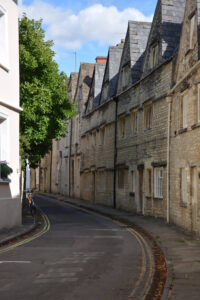
Mention of Coxwell Street brings in another uncertainty. The street seems to follow closely the line of the artificial stream that flows behind the houses on the southern side of the street. I don’t think there can any doubt that this is an artificial diversion of the stream because the streambed cuts through the gravel spine that separates the Daglingworth stream side of the town from the Churn side. From its course alongside the swimming baths it flows behind Coxwell Street, under the perceptible hump of its underground conduit in Dollar Street by the Vicarage and thence to the site of the Abbey Mill opposite.
This presents a chicken and egg question: did the stream follow the back of properties of an existing Anglo-Saxon street, or did twelfth-century Coxwell Street grow up along the line of the stream? An Anglo-Saxon origin is perfectly possible, but I think it would have needed the authority and the resources of the newly founded abbey to dig that stream diversion, which means that the stream bed and the street might both date from the twelfth century.
Before all this happened, the Daglingworth stream probably breached the walls in the post-Roman period in the area where the Mansion now stands and flowed roughly along the old line of Sheep Street and along Trinity Road to form a marsh that might be the origin of the name Watermoor.
That earlier line becomes a feature of the landscape again in the 18th century when the Thames and Severn Canal company dug a canal feeder channel to take water from the stream under Cecily Hill and across the back lawn of the Mansion to top up its ever-leaking canal. It is interesting to speculate on the priorities of the Bathurst family at that time; Earl Bathurst was a major shareholder in the canal company and he owned the canal basin, so perhaps he tolerated the digging of a big trench for a conduit in his back garden in return for the value of the trade that the canal brought to the town.
Back to the Middle Ages, and the next stage in the reorganisation of the settlement of Cirencester comes with the building of the abbey and therefore the need for a separate church for the people of the town. Prior to this, the area that is now the Market Place and Dyer Street seems to have been a strip field for the Anglo-Saxon settlement. The evidence for this can be clearly seen in the S-shaped property and garden boundaries either side of Dyer Street that are clearly shown on the 1795 map of Cirencester. I simply do not believe that the owners collectively and deliberately decided to make their gardens in such a specific shape when the properties either side of Dyer Street and the Market Place were built.
The simplest explanation for their shape is that an old strip field was taken over when the abbey was being built and the parish church was being planned and a new road – today’s Dyer Street – was constructed to link the Fosse Way, the settlement and the projected or new church. This can only mean that the present Market Place dates to the time of the building of the first parish church, if not a little later. This would put Dyer Street and the Market Place into the middle of the 1100s, along with Coxwell Street.
The north (abbey) side of the new road seems to have been granted to, or taken up by, the Archibald family and much of that land remained with them until a few generations before the dissolution of the abbey. The southern (Lewis Lane) side went to, or was leased by, the Pirie family and we have a document of 1250 in the Book of Fees enquiring into the fact that the land has been divided into parts and alienated into separate sections when it ought to be one property belonging to ‘the sergeant’ – that is to say the member of the Pirie family who held the land in return for being responsible for the guarding and safety of the king’s treasury in the county.
It seems that what was intended as a single block of land along the south side of Dyer Street had been either leased or sold during the later 1100s and early 1200s, thus creating a small estate in 1250 of about 25 owners or tenants. The boundaries surviving from the strip field on the map of 1795 do indeed suggest about 25 separate ‘properties’, but obviously not too much weight can be put on this.
Much of this information about early tenants or owners comes from the Book of Fees and from the Lady Chapel Register of the parish church, now in the Bodleian Library, Oxford. The latter dates to about 1460 and seems to have resulted from the efforts of the Wardens of the Lady Chapel of the parish church to establish their property details and make sure that, in the uncertainties of the time, the period now known as the Wars of the Roses, their property ownership rights were firmly established. The names of successive property owners are recorded in the Lady Chapel Register, right back to the 1250s, and some of these tie up with the names of owners or tenants recorded in the Book of Fees. They are thus the earliest known ordinary inhabitants of medieval Cirencester.
Additional references
For an overview, see Neil Holbrook (ed), Excavations and Observations in Roman Cirencester 1998-2007, Cirencester Excavations vol VI, 2008
Richard Reece and Christopher Catling. Cirencester: The Development and Buildings of a Cotswold Town, British Archaeological Reports no. 12, 1975. 98pp. Oxford
Alan McWhirr, Houses in Roman Cirencester, Cirencester Excavations vol III, 1986 (see esp. pp.191-205)
Richard Reece and Peter Broxton, ‘W-Shaped Strips under Cirencester’, Trans Bristol & Glos Archaeological Society, 132, 2014, 125-129 (see refs).
October 2018